Product Description
HISUI raw data is not suitable for users.
And the raw data is processed to produce a formatted product that can be used by the users.
Product Level
In the basic Level 1 product, the necessary corrections are sequentially processed in three steps: 1A, 1R, and 1G. The user is basically provided with a Level 1G product.
Level 2 products are also planned as science products, which will correct the effect of the earth's atmosphere on radiance and convert it to reflectance of surface objects, which will be useful for detection of surface objects and/or conversion to geophysical quantities.
| Name/Format | Description |
|---|---|
| Level 0 | Raw data |
| Level 1A | Raw DN product with all radiometric calibration coefficients. Spatial resampling is not applied. |
| Level 1R | Top-of-atmosphere spectral radiance product. Spatial resampling is not applied. |
| Level 1G GeoTIFF | Geometrically corrected and orthorectified top-of-atmosphere spectral radiance product. Parallax and keystone property correction are considered. |
| Level 2G (Science Product) |
Atmospherically corrected surface spectral reflectance product generated from L1G with QA information. This is Science Product for research purpose and not validated. (TBD) |
Level 1 Product
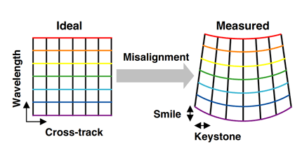
HISUI sensor output data (raw data) data shows the distortion of wavelength and geometry called keystone or smile from the optical system.
This distortion is corrected by Level 1 data processing and Level 1G products with controlled quality of radiance, wavelength, and geometric position, which are then provided to the user.
The Level 1G product is a data set that includes hyperspectral image data (GeoTIFF). Details are described in the Level 1 Product Format Description.
Level 2 Product (Science product)
To promote the use of HISUI data, it is necessary to provide surface reflectance information to users. As the optical instruments capture sun light reflected from the Earth, they are subject to effects of ever-changing atmospheric conditions.
The aim of level 2 processing is to estimate the effects and to determine the accurate surface reflectance. The resulting surface reflectance allows identification of materials for resource exploration, land cover classification, and estimation of physical quantities such as biomass associated with carbon cycle.