2026-02-18>Radiometic Correction Version 4
Radiometric Correction Version 4 has been released. This update improves vertical stripe in low radiance of VNIR image. » Details and History of Topics
HISUI : Hyperspectral Imager Suite
HISUI is a spaceborne hyperspectral imager developed and operated by METI. HISUI was boarded on the Japanese Experiment Module on the International Space Station operated by JAXA in December 2019. And it has been observing the earth since September 2020.
Hyperspectral Data
The most remarkable feature of hyperspectral data is the high spectral resolution. It allows contiguous measurement of reflectance spectra, which show characteristics and physical properties of target materials, across a wide wavelength range.
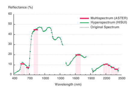
The spectra detectable by multispectral and hyperspectral imager are simulated in the right figure using vegetation (rice paddy in September) as an example.
The imagers assumed here are ASTER (9 bands) and HISUI (185 bands).
This simulation demonstrates that more detailed information can be obtained by the hyperspectral data than the multispectral data as the multispectral imager cannot collect data continuously and thus the spectral signature of unmeasured regions remain unknown.
Potential Applications of HISUI Data

Estimation of Wheat CropView details »
Wheat grain weight and nitrogen content were estimated and crops were classified using data collected by portable and airborne hyperspectral radiometers in Australia.

Coral MonitoringView details »
Discrimination between living corals and sea weed-covered dead corals, which is necessary for coral bleaching and recovery monitoring, has been difficult by the conventional multispectral instruments as they have very similar spectra.

Classification of Rocks and MineralsView details »
Minerals were determined based on the score obtained from spectral correlation used for SFF and SAM techniques and strength of absorption that is specific to each mineral.

Precise tree species classificationView details »
As spectra of trees are very similar, only a limited number of species can be delineated by conventional optical imagery. Tree species were classified using hyperspectral data with a new algorithm based on the chlorophyll absorption, in which the spectral difference of species is most evident.